Report Walkthrough
Location
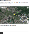
To submit a report you first need to select the location of whatever it is you are reporting.

The map for each report type can be set up to use Google Maps or Open Street Map. The Open Street Map provider can be set up to use different base maps, including ArcGIS and Astun.
When making a report you can type the address, enter a postcode, or move the map pin to select a location. You can also use your current location.
Additional information can be entered in the text area box, which appears once the map pin has been set.
Boundaries
If the report type has been set up to use boundaries, the valid boundary is shown on the map. Attempting to select a location outside of the boundary area displays a warning and pans the valid boundary into view.

Enabling a boundary also restricts the search. This is done by creating a bounding rectangle that contains the boundary and only returning results within that rectangle.
Boundaries are defined using GeoJSON. You can set up a default boundary for all map providers in the Report It configuration, or set a boundary for each provider. A boundary can then be turned on or off per report type. See Additional Configuration for more information.
Confirm Location
Once a user has chosen a location a further, optional page, can be displayed to them. This page displays a zoomed-in area of the map with their pin at the centre. The user is prompted to confirm the exact location of their report before moving on.
This page can be enabled/disabled in the report configuration.


